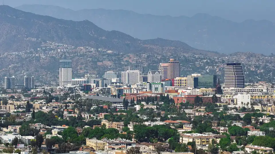
Living in Glendale, CA
Glendale is the 142nd-largest city in the US, home to about 187,000 people in 2025. It has lost 4.8% of its population since 2020. Prices across the metro area run above the national average (113.6 on an index where the US is 100).
- Population, 2025
- 187,160-4.8% since 2020
- Median home value
- $1,102,30012.5 years of median income
- Median rent
- $2,182/morent plus utilities
- Household income
- $88,393median, per year
- Price level
- 113.6US average = 100
- January / July highs
- 68° / 82°lows 49° / 65°
- Average commute
- 27 min21% work from home
- State income tax
- 13.3%top rate, graduated
Been to Glendale?
Added to your city passport. See things to do
Added to the wishlist on your city passport.
County: Los Angeles County
Time zone: Pacific Time (UTC-8, UTC-7 in summer)
Elevation: about 522 ft
Metro area: Los Angeles-Long Beach-Anaheim, CA
Cost of living in Glendale
The median home in Glendale is worth $1,102,300 and the median household earns $88,393 a year, so a typical home costs about 12.5 years of income. Median gross rent (rent plus utilities) is $2,182 a month, about 30% of the median household's income. BEA puts overall prices in the Los Angeles-Long Beach-Anaheim, CA metro area at 113.6, with housing at 170.4 and goods at 106.6 (US = 100). In practice, a $75,000 salary in an average-priced place stretches about as far as $85,200 here. California taxes wages at a top rate of 13.3%. The average combined state and local sales tax in California is 9.03%.
What would my salary be worth in Glendale?
Glendale weather
Average highs run from 68°F in January to 82°F in July, and January nights average 49°F. It gets 14 inches of rain and melted snow a year, with almost no snow. The most comfortable months are January to December.
Month-by-month weather and the best time to visit Glendale
People and work
The median resident is 41.4 years old, and 47% of adults 25 and older hold a bachelor's degree or higher. 35% of households own their home. The average one-way commute is 27 minutes; 21% of workers work from home.
- Median age
- 41.4485th youngest of 546
- Bachelor's or higher
- 47%adults 25+
- Homeowners
- 35%of households
- People per sq mile
- 6,14130.5 sq mi of land
- Take transit to work
- 2%3% walk, 0.4% bike
- Unemployment
- 8.3%2020-2024 average
- Poverty rate
- 12.9%of residents
- Typical home built
- 1966median year
Who moves to Glendale, and where people go
From farther away, newcomers most often come from San Bernardino (San Bernardino County), Riverside (Riverside County) and San Diego (San Diego County). People who leave for somewhere more than 100 miles away most often head to San Bernardino (San Bernardino County), Riverside (Riverside County) and Las Vegas (Clark County). See the map and full lists
IRS county-to-county migration, 2022 to 2023 tax years. Where Americans are moving.
Natural hazards, home prices and air quality
Natural hazard risk
Very High
FEMA rating for Los Angeles County, scored against every US county. Biggest risks: wildfire, inland flooding, earthquake, lightning.
Home prices
+1.2% in a year
Up 32% over five years. FHFA house price index for the Los Angeles-Long Beach-Glendale, CA (MSAD) area, 2026 Q2.
Air quality, 2025
11% good days
99 days unhealthy at least for sensitive groups. EPA daily air quality index for the Los Angeles-Long Beach-Anaheim, CA area (365 days measured).
FEMA National Risk Index (December 2025) combines expected losses from 18 natural hazards with how vulnerable and resilient the community is. It describes the county, not your street; check flood maps for a specific address at FEMA's Flood Map Service Center.
Parks and sights near Glendale
The best-known parks, museums, zoos and landmarks within about 35 miles. Tap Been or Want to add them to your city passport.
- Dodger Stadium 5 miles
- Angel Stadium of Anaheim 32 miles
- University of California-Los Angeles 12 miles
Places from Wikidata (CC0), linked to each one's official site or Wikipedia article. Check hours and fees before you go.
Airports near Glendale
| Airport | Distance | Passengers boarding in 2024 |
|---|---|---|
| Hollywood Burbank Airport BUR | 7 mi | 3,383,237 |
| Hawthorne Municipal Airport HHR | 16 mi | 6,417 |
| Los Angeles International Airport LAX | 16 mi | 37,760,834 |
| Long Beach Airport LGB | 23 mi | 2,031,810 |
Federal Aviation Administration, calendar year 2024 passenger boardings (enplanements) at commercial service airports. Straight-line distance.
Colleges in and near Glendale
| College | Distance | Undergrads | Net price a year | Graduate |
|---|---|---|---|---|
| University of California-Los Angeles | 12 mi | 33,475 | $14,659 | 93% |
| California State University-Northridge | 17 mi | 32,691 | $6,346 | 57% |
| Mt San Antonio College | 24 mi | 26,140 | $1,676 | 45% |
| Pasadena City College | 8 mi | 21,466 | $16,993 | 48% |
| Santa Monica College | 15 mi | 21,440 | $1,693 | n/a |
| University of Southern California | 9 mi | 20,443 | $33,056 | 90% |
US Department of Education College Scorecard, October 2026 release. Net price is the average yearly cost after grants for students who get federal aid. Graduate: share finishing within 150% of normal time.
Frost dates and fall color in Glendale
Freezing nights are rare here.
NOAA 1991-2020 climate normals for Los Angeles Downtown USC Campus, CA, median (50%) dates. All frost dates for Glendale.
Wildfire smoke in Glendale
From 2021 through 2025, a smoke plume covered Glendale on about 36 days a year, including about 7 days of medium or heavy smoke. Smoke high overhead can turn sunsets red without reaching the ground, so check the air quality reading before you change plans.
NOAA Hazard Mapping System smoke analysis, daily satellite plumes over the city center, 2021 to 2025. Smoke days for every city.
Home internet in Glendale
Census Bureau American Community Survey 2020-2024, table B28002, 72,573 households. Compare every city.
Public schools in Glendale
Downtown Glendale is in this district. Neighborhoods farther out may belong to a different one, so check the address with the district before you buy or rent.
| District | Grades | Students | Schools | Students per teacher |
|---|---|---|---|---|
| Glendale Unified School District | K to 12 | 25,329 | 34 | 23.6 |
Other districts within 10 miles: Los Angeles Unified School District (408,026 students), Montebello Unified School District (19,195 students), Alhambra Unified School District (14,597 students), Burbank Unified School District (14,168 students), Pasadena Unified School District (13,757 students), Culver City Unified School District (6,595 students).
National Center for Education Statistics, school district boundaries and characteristics, 2024-25 school year.
Glendale's twin cities
Cities at least 250 miles away with the closest match to Glendale's weather month by month and its costs (price level, home values and rent).
- San Jose, CA65% matchCompare
- San Leandro, CA65% matchCompare
- Concord, CA63% matchCompare
- Hayward, CA63% matchCompare
Find a twin that is cheaper, warmer or cooler
Stargazing near Glendale
The nearest certified International Dark Sky Places:
Designations by DarkSky International as recorded in Wikidata (CC0). All dark sky places.
Ski resorts near Glendale
- Mount Waterman 23 miles
- Buckhorn Ski Club 24 miles
- Kratka Ridge 25 miles
- Mountain High 36 miles
Straight-line distance. All ski resorts.
Pros and cons of living in Glendale
Data points come from the official sources on this page. Points marked Local come from people who live here, are read by a person before they appear, and are ranked by readers.
Pros
- Data 12 months a year have comfortable weather by our rule.
- Data Winters are warm, with January highs around 68°F.
Cons
- Data Homes are expensive for local pay: the median home costs 12.5 years of median household income.
- Data Everyday prices in the metro run 14% above the US average, mostly because of housing.
- Data California's top income tax rate is 13.3%, among the highest in the country.
- Data Sales tax is high: 9.03% on average with local taxes.
- Data The population has shrunk 4.8% since 2020.
- Data High natural hazard risk in Los Angeles County (FEMA rates it very high), led by wildfire, inland flooding and earthquake.
Glendale report card from locals
0 of 5 reports so far. We show the Glendale report card once 5 residents have rated it, so one opinion never stands in for a whole city. Live here? Add yours.
Rate Glendale (2 minutes)
Lived here once? Map every city you have lived in and see how your homes compare.
Ask a local about Glendale
No questions yet. Thinking about a move? Ask about neighborhoods, schools, winters, traffic or anything else, and people who live in Glendale can answer.
Glendale through locals' eyes
No resident photos yet. Share the view from your street, your favorite park or the city on a good day.
Share a photo
Contributions are read by a person before they appear. We remove ads, links, personal attacks and anything about private people. See the most helpful locals.
Cities near Glendale
| City | Distance | Population | Home value | Price level | |
|---|---|---|---|---|---|
| Burbank, CA | 4 mi | 102,988 | $1,089,100 | 113.6 | Compare |
| Los Angeles, CA | 6 mi | 3,869,089 | $921,200 | 113.6 | Compare |
| Pasadena, CA | 6 mi | 135,804 | $1,093,300 | 113.6 | Compare |
| Alhambra, CA | 8 mi | 79,820 | $857,800 | 113.6 | Compare |
| East Los Angeles, CA | 9 mi | 111,647 | $643,100 | 113.6 | Compare |
| South Gate, CA | 14 mi | 90,071 | $636,300 | 113.6 | Compare |
Straight-line distance between city centers.
Glendale ranks 124th of 144 in our best suburbs of Los Angeles ranking.
Cities with a similar profile
Closest match on climate, price level, size, income and median age, outside the immediate area.
Compare Glendale with another city
Frequently asked questions
Is Glendale a good place to live?
It depends on what you need. The numbers show 12 comfortable months a year; the trade-offs are high prices, expensive homes relative to local incomes, a shrinking population. Compare Glendale side by side with another city to see how it stacks up for you.
What is the population of Glendale?
The Census Bureau estimates Glendale had 187,160 residents on July 1, 2025, compared with 196,523 in April 2020 (-4.8%).
How much do you need to earn to live in Glendale?
Using BEA price levels, a $75,000 salary in an average-priced US city buys about the same as $85,200 in the Glendale area. The median household here earns $88,393.
When is the best time to visit Glendale?
By the 1991-2020 climate normals, January to December are the most comfortable months. July averages 82°F and January 68°F for daytime highs.
What county is Glendale in?
Glendale is in Los Angeles County, California. Source: Census Bureau 2020 geography.
What time zone is Glendale in?
Glendale is on Pacific Time (UTC-8, or UTC-7 during daylight saving time from March to November).
What is the elevation of Glendale?
About 522 feet above sea level at the city center. Elevation varies across the city.
Does California have a state income tax?
Yes. California has a graduated income tax with a top rate of 13.3% for 2026. Some cities add a local income tax, which is not included here.
Sources
Population: Census Bureau Vintage 2025 estimates (July 1, 2025). Income, housing, education and commuting: American Community Survey 2020-2024 5-year estimates for the city of Glendale. Price levels: BEA Regional Price Parities 2024 for the Los Angeles-Long Beach-Anaheim, CA metro area. Weather: NOAA 1991-2020 normals, Los Angeles Downtown USC Campus, CA station; snowfall from Burbank Valley Pump Plt, CA. Taxes: Tax Foundation 2026. How we get our numbers.